Up early and COLD -1C.
Burr…chilly fingers! Got dressed, took down the tents and headed for town. At the end of the campground road is this sign....

We're in a fenced in enclosure for this campground because of the bears. A little weird having to go to a special area to get out. In town we stopped for
gas and at Laggans for a breakfast to go—ham and cheese on a bun and a jalapeno
cheese bundle which turned out to be more like a pizza on a cheese flaky
crust. The onward to the Icefields
Parkway! It’s a crystal clear day today
so great for all the mountains and glaciers ahead!

Frosty up here on the Parkway!
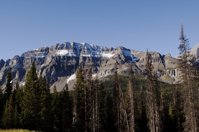
The Columbia Icefield is a sheet of glacial ice trapped by higher surrounding land and feeds more than one glacier. It covers approximately 200 km2 and feeds six large glaciers: Saskatchewan, Castleguard, Dome, Stutfield, Columbia and Athabasca. There's a lot of snow and ice behind those mountains! Every turn of the road has another incredible site so come along with us on this amazing ride...


Bow Lake—beautiful with the Crowfoot
Glacier hanging above it and the Bow river (more a stream here) running
into it.

On to the Num-ti-jah Lodge where the views in front
were stunning. You could see parts of
the Bow River Falls where the Bow River is born from the meltwater tumbling
down from the Wapta Icefield. The Bow
River terminates at Hudson Bay, over 2500 km downstream from Lake Louise.

Peyto Lake (Bow Summit)

Waterfowl Lakes

There
was a merganser family Dad, Mom and 4 babies—more toddlers. Dippers and when they would dip the water
pattern changed to taffeta look. Getting
nice and warm now—we’re down to a shirt and fleece after starting with
5 laayers+mittens+hat. Gotta love sunshine!!!
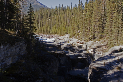
Mistaya Canyon – short downhill hike to a bridge
that crosses the Canyon illustrating the affect water can have on rocks…

These beauties were along the trail.

A very
deep narrow gorge winding around…great, but hard to see it because of the
height of the bridge, but it was wide enough to stick your head through so you
could at least get a fair look.

Howse Pass – It’s a very wide valley where the river
must run wild in the early summer. There
was great signage along the path with remembrances of this area by the
alboriginies that used this land back before the Europeans and the fur traders
came. The tribe allowed traders to use
the pass for one year and then closed it to them and they had to find
another. Mt. Amery and Saskatchewan GOATS on the hill
– 4 of them, one a quite impressive ram.
We had quite a crowd when we left 30 minutes later.


Saskatchuwan River

Mountain Sheep – Mom and 2 little ones right by the side of
the road. They hopped over the guardrail
into the road—sheep jam until they decided which way they were going.

Bridal Veil Falls
We stopped at the Columbia Icefield Tent Campground – got a wonderful
spot by a waterfall and a big platform so both tents fit. Off to the Columbia Icefield Center for the Icefield Adventure. It’s about 3:00 pm and 23C—gorgeous day! Sun is shining on the glacier as we head up
in a regular bus and then switch to our specially designed Ice Explorer.

We begin by decending a 32 degree, 18% grade
road on white and red terabus with it’s 66” tires, by the lateral moraine and
onto the Athabasca Glacier.

We had asked
about weather up here and the lady said only about a 5-10 degree
difference…ha—I don’t think she’s been up there! There
is a constant cold wind that comes off the glacier…fortunately we had brought
several layers and worn our boots. We
had 25 minutes on the ice.


We packed back into the terabus and headed back up the road and up that
steep hill and back to the nice warm weather.

The guide did give us some info – the Athabascan glacier is an outlet
valley glacier that is 6km x 1km and 1000’ thick. It advances 50’ in the winter and receeds 80’
in the summer. We’re at the triple continental
divide – the “hydrographic apex of
America”. Here are the headwaters for
the Columbia River which flows into the Pacific, the Athabascan River that
flows into the Slave to the Mackenzie to the Arctic Ocean and the N.
Saskatchewan River that flows into the Saskatchewan to the Red to the Nelson to
the Hudson Bay and into the Atlantic Ocean.
We got back and did a quick walk through the gift shop (expensive) and
then back to our lovely campground.

We
have a waterfall that is right beside the campsite that we thought was just a
short one…but when you go over to it and out on some of the rocks it’s very
high with a lot of small falls broken by rocky areas…delightful! Dinner out of a freeze-dry bag tonight.


We
took a walk down to the entrance and looked at the marvelous glaciers around
us…what a wonderful spot! Gretchen and I
stayed in the warm car until the stars came out, but couldn’t make it until
real star gazing time! Should be great
sleeping tonight with that falls beside us!